


Voting District 7012, Spokane County, Washington
About
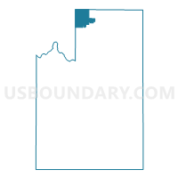
Outline

Summary
| Unique Area Identifier | 689238 |
| Name | Voting District 7012 |
| County | Spokane County |
| State | Washington |
| Area (square miles) | 28.75 |
| Land Area (square miles) | 28.75 |
| Water Area (square miles) | 0.00 |
| % of Land Area | 100.00 |
| % of Water Area | 0.00 |
| Latitude of the Internal Point | 48.00464980 |
| Longtitude of the Internal Point | -117.48069240 |
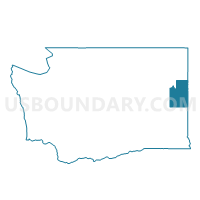
Maps

Graphs
Select a template below for downloading or customizing gragh for Voting District 7012, Spokane County, Washington


Neighbors
Neighoring Voting District (by Name) Neighboring Voting District on the Map
- Voting District 7000, Spokane County, WA
- Voting District 7011, Spokane County, WA
- Voting District 7300, Spokane County, WA
- Clayton 1 Voting District, Stevens County, WA
- Clayton 2 Voting District, Stevens County, WA
- Fertile Valley South Voting District, Pend Oreille County, WA
- Loon Lake 2 Voting District, Stevens County, WA
- Williams Valley Voting District, Stevens County, WA
Top 10 Neighboring County Subdivision (by Population) Neighboring County Subdivision on the Map
- Deer Park CCD, Spokane County, WA (29,319)
- Newport CCD, Pend Oreille County, WA (10,902)
- Loon Lake CCD, Stevens County, WA (10,651)
- Springdale CCD, Stevens County, WA (5,013)
Top 10 Neighboring Place (by Population) Neighboring Place on the Map
Top 10 Neighboring Unified School District (by Population) Neighboring Unified School District on the Map
- Riverside School District, WA (11,407)
- Deer Park School District, WA (10,849)
- Loon Lake School District, WA (1,710)
Top 10 Neighboring State Legislative District Lower Chamber (by Population) Neighboring State Legislative District Lower Chamber on the Map
Top 10 Neighboring State Legislative District Upper Chamber (by Population) Neighboring State Legislative District Upper Chamber on the Map
Top 10 Neighboring 111th Congressional District (by Population) Neighboring 111th Congressional District on the Map
Top 10 Neighboring Census Tract (by Population) Neighboring Census Tract on the Map
- Census Tract 103.04, Spokane County, WA (5,805)
- Census Tract 9513, Stevens County, WA (4,287)
- Census Tract 103.01, Spokane County, WA (4,266)
- Census Tract 103.03, Spokane County, WA (3,022)
- Census Tract 9704, Pend Oreille County, WA (2,682)